Attention: Météo automatique. Ne pas s'y fier aveuglément!
Warning: Automatic forecast. Do not trust blindly!
Warning: Automatic forecast. Do not trust blindly!
Une mise en garde pour les petites embarcations reste en vigueur et sera probablement relevée en avertissement d'ici demain (Anguilla météo). Les baigneurs doivent également faire preuve de prudence.
Situation: Les hautes pressions produisent des alizés de secteur Est devenant progressivement assez forts ou "frais" dans les prochains jours et rendant la mer de plus en plus agitée à forte (2-2,5 m voire 2,7 m). Houle de Nord assez forte possible à partir de jeudi soir ou vendredi. Les alizés peuvent transporter des averses occasionnelles. Brume de sable d'origine saharienne faible avec des petites poches plus intenses.
Prévisions:
Aujourd'hui: assez beau temps mais quelques averses sont possibles jusqu'à la mi-journée et dans la nuit. Beau temps partiellement ensoleillé cet après-midi, plus nuageux cette nuit avec une chance d'averses. Le vent s'est calmé la nuit dernière mais est prévu de se renforcer à nouveau en cours de journée. De fortes rafales sont possibles.
Demain: 1 ou 2 averses matinales. Partiellement nuageux ensuite avec un faible risque d'averses. Vents frais (+rafales) et mer forte prévus.
Vendredi: même scénario
Jours suivants: légère dégradation dimanche ou lundi avec plus de nuages et d'averses mais aussi de belles périodes ensoleillées. Vents assez forts et mer forte.
Dernières 24 h: Partiellement nuageux à très nuageux parfois mais avec de rares et faibles averses. Vents modérés. Fort clapot en baie. Averses éparses à partir de 20 h (approx) jusqu'à ce matin.
En ce moment: Température 23.9 à 7 h. Vents modérés 18-22 km/h ou 10-12 nœuds et un léger clapot en baie. Majoritairement nuageux avec une forte chance d'averses ce matin au moins. Averse modérée vers 7:45 h et 9 h.
Atlantique: Données de la bouée 41044 330 NM (600 km) NE St Martin
Mer des Caraîbes: Station 42060 - Caribbean Valley - 63 NM WSW of Montserrat
Vents, mer & houle: Voir "situation" et ci-dessous (NOAA). Température mer: 25,2 à 26,3°c de l'Atlantique à la Mer des Caraïbes.
Offshore Waters Leeward Islands-
327 AM EST Wed Feb 20 2019
.TODAY...NE to E winds 15 to 20 kt. Seas 6 to 8 ft.
.TONIGHT...NE to E winds 15 to 20 kt. Seas 6 to 8 ft.
.THU...E winds 15 to 20 kt. Seas 6 to 8 ft in E swell.
.THU NIGHT...NE to E winds 15 to 20 kt. Seas 6 to 9 ft in E
swell.
.FRI...E winds 15 to 20 kt. Seas 6 to 8 ft.
.FRI NIGHT...NE to E winds 15 to 20 kt. Seas 6 to 8 ft.
.SAT...NE to E winds 15 to 20 kt. Seas 6 to 8 ft.
.SAT NIGHT...NE to E winds 20 kt. Seas 6 to 8 ft.
.SUN...NE to E winds 15 to 20 kt. Seas 6 to 8 ft.
.SUN NIGHT...NE to E winds 15 to 20 kt. Seas 5 to 7 ft.
Voir ces liens: Nouvelle page vents-mer-houle. Bulletin officiel côtier de Météo-France, Météo Anguilla, Windguru, Prévisions mer, vent houle à Marigot + d'autres liens en bas de page.
--------------------------------------------------------
WARNING... A small craft caution remains in effect and will likely be ungraded to a small craft advisory by tomorrow (Anguilla wx). Sea-bathers should exercise caution too.
Synopsis: The high pressures produce easterly to NE trade winds becoming gradually fresh during the coming days and making the sea more and more choppy to rough (7-8 ft or even 9 ft). Quite heavy North swell possible from Thursday evening or Friday. Trades can transport occasional showers. Weak Saharan sand dust haze with more dense small pockets.
Forecast
Today: good weather but some showers are possible until mid-day and at night. Partly sunny this afternoon. Then, more cloudy with a slight chance of night showers. Light wind could strengthen again later producing rough seas. Strong gusts possible.
Tomorrow: 1 or 2 morning showers. Then partly cloudy with a low chance of showers.
Friday: Little change
Following days: slight deterioration from Sunday or Monday with more clouds and showers but also large sunny periods. Fresh winds with higher gusts and rough seas.
Last 24 hours: Partly cloudy to mostly cloudy at times, but with few showers. Moderate winds up to 17 kts. Choppy sea in the bay. Scattered showers starting at 8 pm (approx) until this morning.. More information with NOAA history
Atlantic: Station 41044 330 NM NE St Martin
Caribbean Sea: Station 42060 - Caribbean Valley - 63 NM WSW of Montserrat
Right now (8 am): Mostly cloudy with showers in the vicinity, moderate E winds 18-22 km/h or 10-12 kts. Light chop in the bay. More information with NOAA history
Last minute: showers around 7:45 am and 9:00 am.
Thunderstorms: weatherbug.com
Winds and seas:
Offshore Waters Leeward Islands-
327 AM EST Wed Feb 20 2019
.TODAY...NE to E winds 15 to 20 kt. Seas 6 to 8 ft.
.TONIGHT...NE to E winds 15 to 20 kt. Seas 6 to 8 ft.
.THU...E winds 15 to 20 kt. Seas 6 to 8 ft in E swell.
.THU NIGHT...NE to E winds 15 to 20 kt. Seas 6 to 9 ft in E
swell.
.FRI...E winds 15 to 20 kt. Seas 6 to 8 ft.
.FRI NIGHT...NE to E winds 15 to 20 kt. Seas 6 to 8 ft.
.SAT...NE to E winds 15 to 20 kt. Seas 6 to 8 ft.
.SAT NIGHT...NE to E winds 20 kt. Seas 6 to 8 ft.
.SUN...NE to E winds 15 to 20 kt. Seas 6 to 8 ft.
.SUN NIGHT...NE to E winds 15 to 20 kt. Seas 5 to 7 ft.
Sea surface temperature (SST): 25.4 to 26.3 ° C (77.3 to 79.3°F) from the Atlantic to the Caribbean Sea. Look at New Winds-seas-swells page, Official coastal bulletin (Meteo-France in French*), Météo Anguilla, Windguru, +other links bottom of page.
*Sorry, automatic translation generally doesn't work well for this page due to scripts probably. Please, copy the text in clipboard then past it into Google Translate.
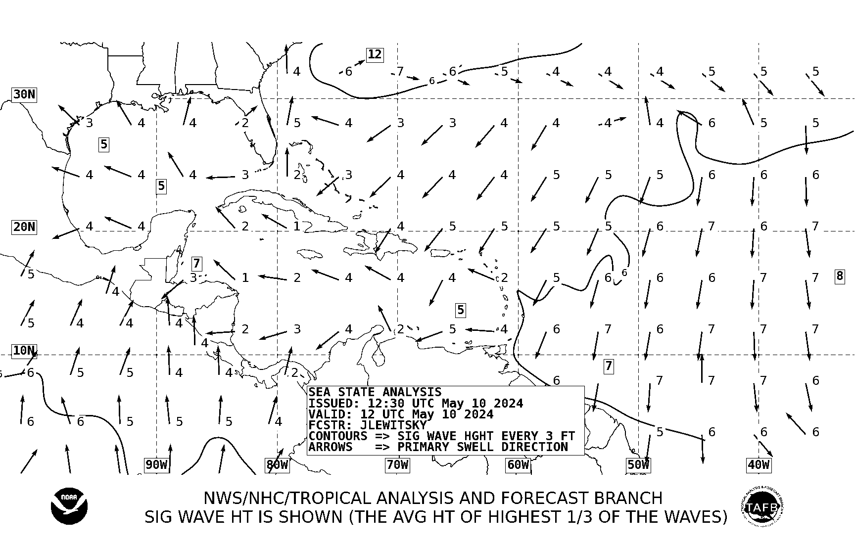 |
| Direction houle et creux en pieds (prochaines 24 h) | Swell direction and heights in feet (next 24 hours) |
Navires | Ships:
- https://www.marinetraffic.com/en/ais/home/centerx:-63.090/centery:18.069/zoom:13
- Yachts owners | Propriétaires de yachts: https://www.superyachtfan.com

NOUVEAU!
- Webcam "live" de Great Bay (Philipsburg). Vous pouvez aussi y accéder ici en plein écran: https://www.youtube.com/embed/Sx2jwG4ypMs
- Live Webcam de l'aéroport Princess Juliana: https://www.mahobeachcam.com/ (attention! ne fonctionne pas avec un bloqueur de pub. Utilisez plutôt un navigateur minimaliste sans ad-blocker comme Min sous Windows ou Surf sous Linux.)
- Live Webcam de St. Peter's Hill (impressionnante vue générale de l'aéroport): http://www.sxmislandcam.com/
- Live Webcam du port de Philipsburg montrant les paquebots: https://www.portstmaartenwebcam.com/
- Webcam de récif aux Îles Caïman: https://www.youtube.com/embed/bz-D_aFqSlM. En "plein écran", cela peut faire un superbe économiseur d'écran.
- Retour de la fameuse webcam du Sunset Beach Bar & Grill (webcam seule): http://192.99.149.103:8080/sunset/embed.html Attention, le son des avions et les communications pilote <-> tour de contrôle ont disparu (musique seulement, mais vous pouvez les retrouver sur la webcam de l'aéroport).
Bien-entendu, vous pourrez aussi voir ces webcams depuis votre Smartphone, Iphone ou autres et mettre les liens en page d'accueil. Je remettrai la webcam du NBBC en action dès que j'aurai retrouvé une bande-passante illimitée.
*Min est multi-plateforme c'est à dire disponible pour Linux, Windows and macOS
*Min est multi-plateforme c'est à dire disponible pour Linux, Windows and macOS
VIGILANCES MÉTÉO-FRANCE
The best automatic site: Windy.com based on the best model, ECMWF or "Euro" and yet free. Warning, however, winds may not display well in some browsers like Chrome/Chromium and its forks. Displaying well in Firefox and alternatives and especially in the minimalist Surf-Browser (Linux only). Click on "Marigot" if detailed forecasts are not displayed.
Animation satellite infra-rouge centrée sur St Martin
 NEXT HURRICANE SEASON will start on june 1st 2019.
LA PROCHAINE SAISON CYCLONIQUE commencera le 1er juin 2019
Sites officiels | Official websites: NHC et Météo-France. Traduction automatique NHC
Météo-France Communiqué d'Actualité Cyclonique.
Attention! Les traductions automatiques sont faites avec Google Traduction donc les résultats peuvent être parfois étranges... Mais ça donne une idée. Les bulletins se mettent à-jour automatiquement.
- Windy.com (sous Linux, utilisez de préférence les navigateurs Firefox ou le minimaliste Surf). Utilise par défaut le modèle ECMWF "Euro", excellent)
- Météo-France Antilles-Guyane (Officiel. Automatique. Prévisions moyennement fiables)
- VIGILANCE: suivi_iles_nord.pdf Indispensable | English translation.
- Météo Anguilla (précis. pour les prochaines 24 h seulement)
- Sint-Maarten forecast (Weather.com via Google. Automatique)
- Weather.com
- Meteorological Department St. Maarten
- Historique météo 72 h | 72 hours wx history (NOAA)
VENTS MER HOULE | WINDS SEAS SWELLS
- Bulletin côtier Météo-France (Coastal forecast. Pour les plaisanciers. Assez bon)
- Windguru Baie de Marigot (important pour la houle notamment).
- Windguru St. Martin Wilderness (spot connu de surf face à Tintamarre)
- Windguru Anguilla Long Bay
- Nouvelle page vents-mer-houle | Webmaster's swell page
CYCLONES
- NHC (officiel pour les cyclones. En Anglais). Traduction automatique en Français.
- Tropical Tidbits (Modèle ECMWF "Euro")
- Météo-France Cyclones (officiel) Translation.
- Préfecture
- Collectivité (COM)
DIVERS | MISC
- Navires en baie | Vessels in bay: marinetraffic.com
- Site du NBBC
- CS du NBBC