HIVER | WINTER
Situation: Hautes pressions au nord donnant un temps plutôt stable mais les alizés peuvent apporter quelques averses isolées surtout la nuit et le matin. De plus, un creux de surface devrait passer dans les prochaines 12 h. Weekend plus humide et baisse des températures. Vents et mer se renforçant de vendredi à dimanche.
Dernières 24 h: très nuageux avec quelques averses isolées. Vents d'Est modérés à légers. Un peu de houle de nord croisée avec la mer du vent.
Actuellement (7:30): Moyennement nuageux avec un petit risque d'averses isolées. Vents d'Est environ 15 km/h / 8 nd avec des rafales. Mer belle en baie avec un peu de clapot. Température 25° à 7 h et 26° à 8 h. Humidité: 74%. Température mer: 26°c environ. Observations & historique (NOAA): TNCM
(TNCM est le code ICAO de l'aéroport Princess Juliana).
Dernière minute: averses vers 8:35 h et 9:05 h
Aujourd'hui et nuit prochaine: Assez nuageux ce matin avec une chance d'averses. Plus ensoleillé et dégagé en cours de journée avec un faible risque d'averses. Averses plus fréquentes la nuit prochaine au passage d'un talweg (creux).
Jours suivants: Un peu plus humide avec surtout des averses nocturnes et matinales. Weekend: possiblement très nuageux avec un bon risque d'averses de vendredi à lundi. Vents assez forts et mer agitée à forte de vendredi à dimanche. Températures pouvant tomber à 24°C.
Vents, Mer, houle: Vents modérés à frais d'est et mer agitée au large. Se renforçant significativement de jeudi soir ou vendredi à dimanche et mer devenant très agitée à forte.
Mer du vent d'Est 1,5 m (actuellement). Houle de NO (NW), 2 m et 9-11 secondes croisée avec la mer du vent.
Voir liens ci-dessous et nouvelle page vents-mer-houle.
Liens: Nouvelle page vents-mer-houle. Bulletin officiel côtier de Météo-France, Météo Anguilla, Windguru, Prévisions mer, vent houle à Marigot + d'autres liens en bas de page.
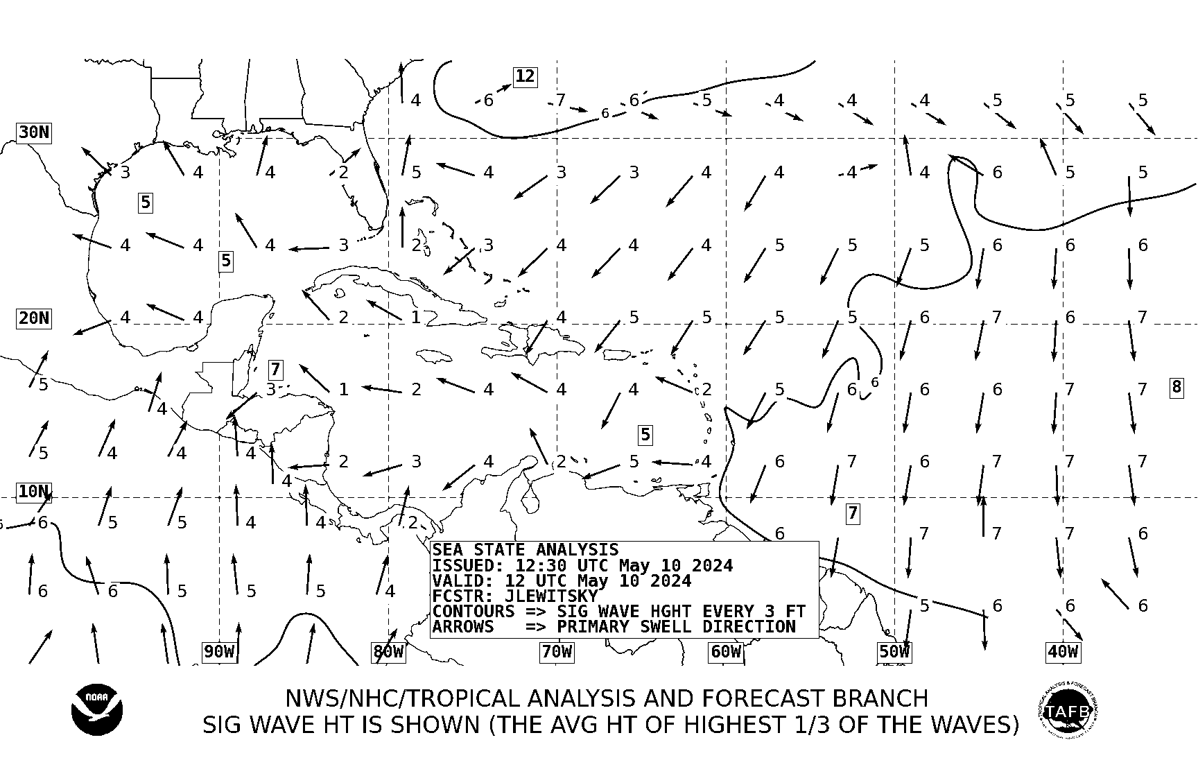 |
| Direction houle et creux en pieds (prochaines 24 h) | Swell direction and heights in feet (next 24 hours) |
Navires | Ships:
- 1 seul super-yacht: Lazy Z, 51,4 m. Propriétaire: Mortimer Zuckerman (Canadien/Américain)
- Un cargo à Galisbay
- Orion (Ro-Ro), un habitué.
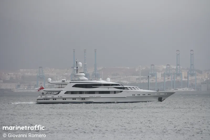 |
| Lazy Z |
- --
--------------------------------------------------------
Synopsis: High pressures north of our region producing a generally stable weather. But trade winds could bring some isolated showers from time to time. In addition, a trough is expected to cross the region tonight. Stronger winds, rough seas and lower temperatures are expected during the weekend.
Last 24 h: Cloudier with a few showers. Moderate to light E winds. Some northerly swell.
Currently (9 am): Mostly cloudy with scattered showers. NorthEast W 16 km / h / 8 kts. Smooth to slightly choppy sea in the bay. Temperature 25 ° at 7 am and 27° at 9 (77-80.6°F). Humidity: 70% (-). Sea temperature: 26-25 ° C. Observations & History (NOAA): TNCM. Observations & History (NOAA): TNCM. (TNCM is the Juliana Airport's ICAO code)
Last minute: Brief moderate showers at 8:35 & 9:05 am.
Today/Tonight: Mostly cloudy this morning with a few sunny spells but also a few isolated showers possible. More sunny later during the day but new showers are possible during the night.
Next few days: Few changes. Partly cloudy to mostly cloudy with a chance of isolated night and morning showers from Friday to Sunday and beyond maybe. Temperatures may decrease at 24 ° C or 75° F.
Winds, seas, swells: Light to possibly fresh winds from east or so, strengthening from Thursday evening or Friday to Sunday. Strong gusts ahead of the showers.
Easterly wind sea 1,5 m or 5 ft possibly mixed with NNW swell. Seas expected to become rough from Friday.
Look at New Winds-seas-swells page. Official coastal bulletin (Meteo-France in French*), Météo Anguilla, Windguru, +other links bottom of page.
*Sorry, automatic translation generally doesn't work well for this page due to scripts probably. Please, copy the text in clipboard then past it into Google Translate.
- Small craft operators, mariners and sea bathers should exercise caution mainly on & along eastern to northern shores of the islands.
VIGILANCES MÉTÉO-FRANCE
The best automatic site: Windy.com based on the best model, ECMWF or "Euro" and yet free. Warning, however, winds may not display well in some browsers like Chrome/Chromium and its forks. Displaying well in Firefox and alternatives and especially in the minimalist Surf-Browser (Linux only). Click on "Marigot" if detailed forecasts are not displayed.
Animation satellite infra-rouge centrée sur St Martin
 NEXT HURRICANE SEASON will start on june 1st 2019.
LA PROCHAINE SAISON CYCLONIQUE commencera le 1er juin 2019
Sites officiels | Official websites: NHC et Météo-France. Traduction automatique NHC
Météo-France Communiqué d'Actualité Cyclonique.
Attention! Les traductions automatiques sont faites avec Google Traduction donc les résultats peuvent être parfois étranges... Mais ça donne une idée. Les bulletins se mettent à-jour automatiquement.
- Windy.com (sous Linux, utilisez de préférence les navigateurs Firefox ou le minimaliste Surf). Utilise par défaut le modèle ECMWF "Euro", excellent)
- Météo-France Antilles-Guyane (Officiel. Automatique. Prévisions moyennement fiables)
- VIGILANCE: suivi_iles_nord.pdf Indispensable | English translation.
- Météo Anguilla (précis. pour les prochaines 24 h seulement)
- Sint-Maarten forecast (Weather.com via Google. Automatique)
- Weather.com
- Meteorological Department St. Maarten
- Historique météo 72 h | 72 hours wx history (NOAA)
VENTS MER HOULE | WINDS SEAS SWELLS
- Bulletin côtier Météo-France (Coastal forecast. Pour les plaisanciers. Assez bon)
- Windguru Baie de Marigot (important pour la houle notamment).
- Windguru St. Martin Wilderness (spot connu de surf face à Tintamarre)
- Windguru Anguilla Long Bay
- Nouvelle page vents-mer-houle | Webmaster's swell page
CYCLONES
- NHC (officiel pour les cyclones. En Anglais). Traduction automatique en Français.
- Tropical Tidbits (Modèle ECMWF "Euro")
- Météo-France Cyclones (officiel) Translation.
- Préfecture
- Collectivité (COM)
DIVERS | MISC
- Navires en baie | Vessels in bay: marinetraffic.com
- Site du NBBC
- CS du NBBC