VIGILANCE JAUNE Fortes pluies et Orages
http://www.meteofrance.gp/integration/sim-portail/generated/integration/img/produits/pdf/suivi/bulletin_suivi_iles_nord.pdf
Extrait:
Niveau de vigilance : JAUNE | Danger : Fortes pluies et Orages
Bulletin de suivi n°3 pour les Iles du Nord : Saint-Martin et Saint-Barthélemy émis le : lundi 28 mai 2018 à 05h47 légales (soit 09:47 UTC)Par : Centre Météorologique de Guadeloupe
Date et heure du prochain bulletin : lundi 28 mai 2018 vers 06h légales.
Début d'évènement : En cours.| Fin d'évènement estimée : Lundi 28 mai 2018 à 17h légales.
Situation actuelle
Des fortes cellules orageuses, provoquées par l'interaction d'un air chaud et humide remontant du Sud-Est
et d'un air assez froid en altitude stagnent près du Nord de l'arc antillais.
Prévisions
Après une accalmie cette nuit, il persiste une probabilité, plus forte en matinée de voir de nouveaux orages atteindre nos îles. Compte tenu des quantités d'eau déjà tombées, toute averse orageuse survenant ces prochaines heures entrainerait de nouveaux débordements. Malgré des périodes d'accalmie voire de beau temps, une réelle amélioration des conditions sur la zone avec évacuation de tout risque orageux n'est pas envisagée avant la fin de journée.
Données observées
Pas de données significatives, cette nuit sur Saint-Martin et Saint-Barthélemy.
METEO-FRANCE'S YELLOW WATCH FOR THUNDERSTORMS AND HEAVY SHOWERS
Excerpt:
YELLOW WATCH | Danger: Heavy rain and thunderstorms
bulletin #3 for the Northern Islands: Saint-Martin and Saint-Barthélemy issued on: Monday, May 28, 2018 at 05h47 local (ie 09:47 UTC) By: Centre Meteorologique de Guadeloupe.
Date and time of the next bulletin: Monday, May 28, 2018 around 06h legal.
Start of event: In progress. Estimated end: Monday, May 28, 2018 at 17h local.
Current situation
Strong thunderstorm cells, caused by the interaction of hot, humid air from the Southeast and with a rather cold air at altitude, stagnate near the North of the West Indies arc.
Forecasts
After a lull last night, there is still a likelihood, stronger in the morning to see new storms reach our islands. Given the amount of water already fallen, any stormy shower occurring in the coming hours would lead to further flash floods. Despite periods of lull or even good weather, a real improvement of the conditions on the area with evacuation of stormy risks is not expected before the end of the day.
Follow Alberto | Suivez l'évolution d'Alberto: https://www.nhc.noaa.gov/

VIGILANCES & ALERTES (click image if our islands in yellow)
WATCH, WARNING & ALERT (clic sur l'image si nos îles sont en jaune)
Bonjour à toutes et à tous!
Prévisions cycloniques: RIEN NE MENACE NOTRE RÉGION. Une onde tropicale passe actuellement sur notre région. Tempête sub-tropicale Alberto abordant actuellement le nord-ouest de la Floride et l'Alabama.
Météo régionale: Une onde tropicale en interaction avec de l'air froid en altitude pourrait provoquer des averses encore aujourd'hui à demain matin.
Vents et Mer: Vents faibles à légers se renforçant un peu & mer belle devenant agitée voire localement forte.
Attention!
- Attention en mer et sur les plages orientales notamment.
- Tempête subtropicale Alberto proche de la Floride. Ce système ne menace aucunement notre région. Traduction automatique du bulletin du NHC ou original en Anglais.
- Une onde tropicale pourrait produire encore un peu de mauvais temps aujourd'hui. Attention aux possibles inondations soudaines.
Cette image change plusieurs fois par jour | This image refreshes several times a day
Clic sur l'image pour l'animation | Click image to get the loop
|
Tropical weather: NO THREAT TO OUR REGION. A tropical wave is crossing on our region. Sub-tropical storm Alberto landing on Northwestern Florida & Alabama.
Regional wx: A tropical wave interacting with high level cold air could cause showers again today to tomorrow morning.
Winds & seas: Light winds could reinforce & slight seas could become moderate to even locally rough.
Warning(s):
- Caution at sea & on eastern shores.
- NHC: http://forecast.weather.gov/product.php?site=NWS&issuedby=AT&product=TWO&format=txt
- A Tropical wave could produce a bit of bad weather over our region from today to Tuesday morning. Beware of possible flash floods.
Photo du jour (peut changer en cours de journée) | Picture of the day (can change later)
Infra-Rouge Caraïbes | Caribbean IR
| Sea water temp | Température mer |
Si vous recevez cette page par courriel, vous ne verrez peut-être pas toutes les images et animations satellite. Si vous voulez en profiter pleinement, cliquez ici: Bulletins du webmaster
If you receive this page by email, you will not see satellite images and loops maybe. If you want to enjoy it fully, click here: Webmaster's forecast
10 noeuds (10 nd) = 18,52 km/h
Les navigateurs doivent consulter avant-tout la météo marine officielle: Bulletin Côtier & Large de Meteo France.
- HIER/NUIT DERNIÈRE: Ciel très nuageux et plusieurs averses légères jusqu'à la mi-journée. Fortes pluies et orages sur St Barth. Assez beau l'après-midi et nuit. Mer belle à peu agitée en baie. Vents légers à modérés d'Est à SE.
- OBSERVATIONS CE MATIN ENTRE 7-9 H. Partiellement ensoleillé devenant plus nuageux avec une faible menace d'averses. Vents modérés d'Est env 22 kmh avec des rafales à 30-40 kmh, mer belle en baie. Vérifiez bien la date et les heures (3 dernières heures). Pour des données actualisées cliquez sur les liens plus bas.
- DERNIÈRE MINUTE: ---
Liens observations
http://www.iflightplanner.com/W/Wx/?ID=tncm&MPA=VAF
http://w1.weather.gov/data/obhistory/metric/TNCM.html (ne fonctionne plus actuellement)
http://w1.weather.gov/data/obhistory/metric/TNCM.html (ne fonctionne plus actuellement)
OBSERVATIONS AUTOMATIQUES (visibles seulement sur le site, pas dans les emails)
Une certaine dégradation du temps est attendue au passage d'une seconde onde tropicale. Il n'est pas impossible qu'elle se dissipe prochainement. une nouvelle onde de vrait arriver dans environ 4 jours et une autre en début de semaine prochaine.
- AUJOURD'HUI: Le ciel pourrait devenir de plus en plus nuageux. Averses faibles à modérées pouvant être fortes avec un risque orageux et de fortes rafales. Mer belle à peu agitée devenant agitée à peut-être très agitée.
- MARDI: averses encore orageuses possibles le matin, assez beau temps ensuite avec de rares averses. Vents et mer, peu de changements.
- JOURS SUIVANTS: Assez beau T avec de rares averses... Vents et mer devraient se calmer de nouveau à partir de mercredi.
- WEEKEND: Une nouvelle Onde Tropicale / perturbation devrait arriver aux alentours de vendredi-samedi avec de fortes pluies possibles et peut-être des orages. Amélioration dimanche.
- VENTS & MER: Les navigateurs doivent consulter avant-tout la météo marine officielle: Bulletin Côtier & Large de Meteo France. Température de la mer: 26°C.
- HOULE DOMINANTE / MER DU VENT: page houle.
- MARÉES ST MARTIN: Voir Lien.
- NAVIRES: Vessel Finder (voir les navires dans la baie).
---------------------------------------------------
- FRANCE: carte prévisions: Meteo en France
- Ci-dessous: Prévisions Foreca pour Paris / CDG
MÉTÉO CYCLONIQUE
- NHC: Tempête tropicale Alberto: Traduction automatique du bulletin du NHC ou original en Anglais.
- Onde Tropicale 2: passe actuellement notre région. Se dissipe en se joignant à un creux.
- Onde Tropicale 3: Arrivée dans 4 jours environ (Vendredi).
- Onde Tropicale 4: Arrivée dans 6-7 jours environ (Début de semaine prochaine).
Note: certaines ondes tropicales (OT ou TW en Anglais) peuvent être faibles ou passer très au sud voire se dissiper (souvent en début et fin de saison)
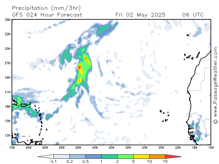
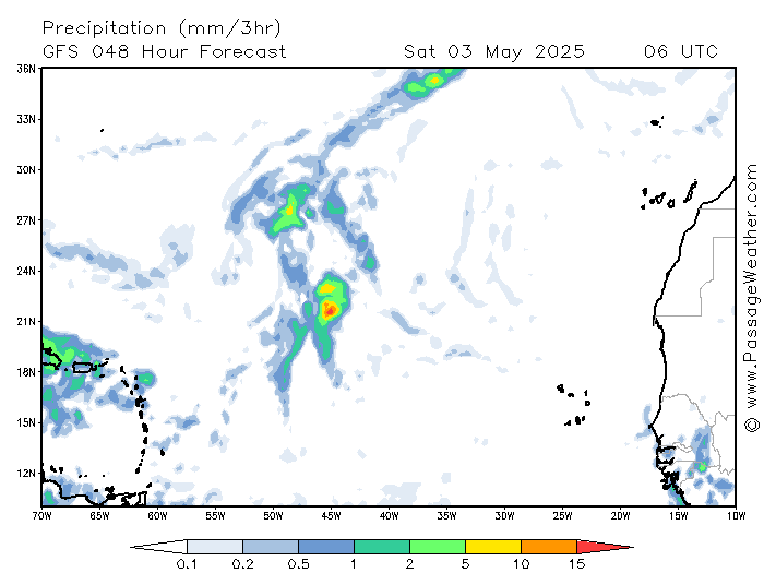
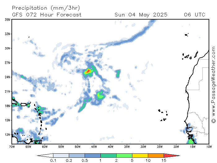
Ondes Tropicales dans 24, 48 & 72 h | Tropical Waves within 24, 48, & 72 h


La saison officielle démarre le 1er Juillet pour les Antilles Françaises
et le 1er Juin pour les autres régions. Cependant des cyclones de pré-season
peuvent se produire et cela n'a rien d'anormal (14 depuis 1981).
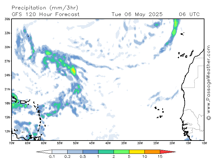
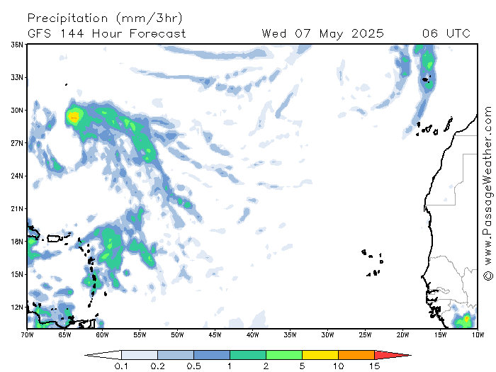
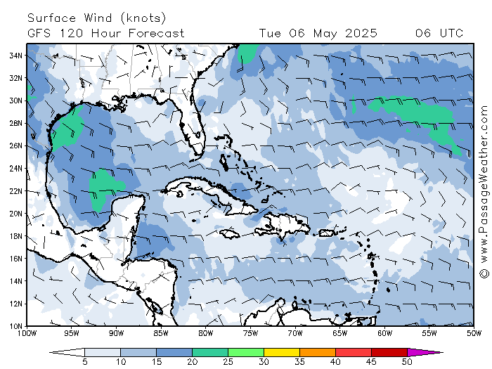
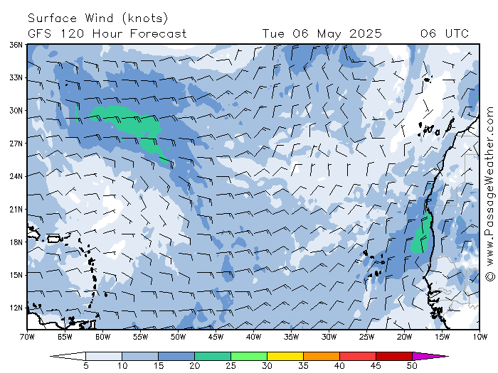
Cartes vents de PassageWeather.com dans 5 jours | Winds maps from PassageWeather.com within 5 days
Permettent de détecter une perturbation en formation | Allow to detect a disturbance in formation
Caraïbes et Golfe du Mexique | Caribbean sea and Gulf of Mexico ||| Atlantique Tropical et Afrique | Tropical Atlantic & Africa
 |
| Capture dans Wikipedia. Les liens ne fonctionnent pas https://en.wikipedia.org/wiki/2018_Atlantic_hurricane_season |
NCSU: (moyenne entre parenthèses)
TWC: Weather Channel
TWC: Weather Channel
* les plus réputés pour les prévisions cycloniques
5 DAYS FORECAST
10 knots=18,52 kph=11.5 miles
Mariners should foremost consult the official marine weather: Meteo-France's offshore bulletin (in English); Coastal bulletin (in French); Anguilla Weather & NHC, Tropical Weather Discussion.
LEEWARD ISLANDS
- YESTERDAY: Partly cloudy to mostly cloudy or even overcast with only a few light showers until midday. Fairly good during afternoon. Smooth to slight sea in the bay. Light to moderate easterly winds with a few occasional strong gusts.
- CURRENTLY, 7-9 (Am): Partly cloudy becoming mostly cloudy with a moderate chance of showers. E winds increasing a bit. Seas becoming slight in the bay. Check the date and time (last 3 hours). For updated data click on the links below.
- LAST MINUTE: Nothing to report
- THUNDERSTORMS: WheatherBug Spark application and its useful mobile app.
OBS LINKS:
http://www.iflightplanner.com/W/Wx/?ID=tncm&MPA=VAF
http://w1.weather.gov/data/obhistory/metric/TNCM.html
http://w1.weather.gov/data/obhistory/metric/TNCM.html
More instable conditions due to a Tropical Wave stagnating over the region. It could dissipate soon. Another one should approach around Friday and a third one early next week.
- TODAY: heavy or stormy showers possible this morning improving slightly this afternoon. Winds could increase a bit. Seas becoming moderate to occasionally & locally rough maybe.
- TOMORROW: Morning: Showers still potentially stormy at sunrise, then decreasing. Winds and sea: few changes.
- FOLLOWING DAYS: Pretty good wx from Wednesday to early Friday with a low chance of passing showers especially from evening to morning ... Winds and sea calming down again.
- WEEKEND: A new Tropical Wave should around Friday and bringing some weather deterioration. Temporary improvement on Sunday.
- EARLY NEXT WEEK: new TW (#4) bringing some bad weather maybe.
- Mariners should foremost consult the official marine weather: Meteo-France's offshore bulletin (in English); Coastal bulletin (in French); Anguilla Weather & NHC, Tropical Weather Discussion.
- Below, relatively reliable automatic forecasts from www.foreca.com. From top to bottom: Day, date, hours, weather, temperature (in red), precipitations (inches) and winds (direction and speed in mph)
- WINDS & SEAS: Mariners should foremost consult the official marine weather: Meteo-France's offshore bulletin (in English); Coastal bulletin (in French); Anguilla Weather & NHC, Tropical Weather Discussion. Sea temperature: 25->26 ° C.
- PRIMARY SWELL / WIND SEA: See the swell page.
- TIDE, ST MARTIN: go to this Link.
- SHIPS: Vessel Finder
---------------------------------------------------
- OTHER INFORMATION: ---
TROPICAL WEATHER
2018 hurricane season
Hurricane season start on July 1st for French Antilles & June 1s for other countries including USA. However, pre-seasonal cyclones can occur.
NCSU: (average in parentheses)
TROPICAL WEATHER
- NHC: Tropical Weather Outlook. Tropical storm Alberto.
- Tropical Wave #2: currently stagnating over our region
- Tropical Wave #3: around Friday.
- Tropical Wave #4: early next week.
LIENS BULLETINS MARINE / LINKS FOR MARINERS
- Voir + de détails sur meteo france marine et Meteo-France Large. Aussi BMS côtier (Bulletin Marine Spécial) si nécessaire.
- Etat de la mer avec les webcams de St Barth.
- Ci-dessous: houle à la bouée 41044 à 600 km au Nord-Est de St Martin (cliquez sur les images our les agrandir):
- Swell at buoy #41044 330 nm NE of St Martin
- Detailed forecast on meteo france marine (Fr), Meteo-France Large (Fr & En) and Anguilla (en). Look also to BMS côtier (coastal) if necessary (Special Marine Bulletin)
- Seas conditions with St Bath's webcams.
Vents et mer dans 24 h (creux en pied. 1 pied=30 cm). 1/2 barbule=5 nd. 1 barbule=10 nd)
Winds and seas within 24 h (height in feet. 1/2 barb=5 kts. 1 barb=10 kts)
Houle dans 24 h (direction et période) | Swell within 24 h (direction and period)
Autres données mer | Other seas data: https://tinyurl.com/houle-swell
SANTE | HEALTH
Actualité santé St Martin. Actualité Santé St Barth. (Health news in french). To translate it, use DeepL.com, the best automatic translator in the world!
|
||||||||
AIDE | HELP
Raccourcis clavier pour recharger une page sans vider le cache de votre navigateur.
Keyboard shortcuts to reload a page without emptying your browser cache.
| Navigateur | Browser | Raccourcis | Shortcuts |
|---|---|
| Firefox | Ctrl + F5 ou/or Ctrl + R |
| Google Chrome | Ctrl + F5 ou/or Maj + F5 |
| Safari | Ctrl + Alt + E |
| Internet Explorer | Ctrl + F5 |
| Opera | Shift ou Maj + F5 |
https://fr.wikipedia.org/wiki/Cache_web: note: un des raccourcis donné par Wikipedia pour Google Chrome ne fonctionne plus ou pas sur Linux. Je l'ai retiré dans le tableau ci-dessus. Maj+F5 fonctionne très bien. Opera permet de personnaliser facilement les raccourcis clavier et souris.
https://en.wikipedia.org/wiki/Wikipedia:Bypass_your_cache
retour à miniNBBCmeteo