Recevoir les bulletins par courriel - Get forecasts via email
VIGILANCES & ALERTES (click image if our islands in yellow)
WATCH, WARNING & ALERT (clic sur l'image si nos îles sont en jaune)
Bonjour à toutes et à tous!
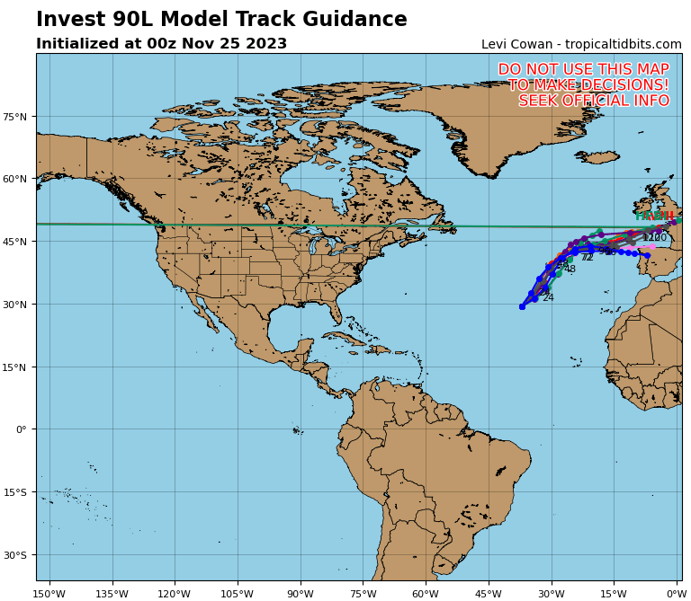
Prévisions cycloniques: RIEN NE MENACE NOTRE RÉGION. Une onde tropicale passe actuellement plus au sud. 2e OT sur l'Atlantique tropical central. Arrivée en fin de semaine (pourrait bien nous affecter). Cyclones: potentiel modéré de formation sur le sud du Golfe du Mexique (0-40%) en fin de semaine.
Météo régionale: onde tropicale traversant la moitié sud des Petites Antilles et pouvant avoir une petite incidence sur notre météo. Elle devrait se dissiper rapidement.
Vents et Mer: Vents modérés à assez forts & mer très agitée à localement forte.
Attention!
- Un système entre la Jamaïque et le Yucatan quelques chances de développement et pourrait apporter des fortes pluies sur la Louisiane et la Floride dans quelques jours . Ce système ne menace aucunement notre région.
- Prudence conseillée aux petits bateaux et au baigneurs sur les côtes Est.
- Vigilance Jaune pour Guadeloupe et Martinique (orages et fortes averses possibles).
Clic sur l'image pour l'animation | Click image to get the loop
|
Tropical weather: NOTHING THREATENS OUR REGION. A Tropical wave crossing the Windward islands and Venezuela could affect marginally our islands. Yellow Watch for Guadeloupe & Martinique islands (Thunderstorms and heavy showers possible). A second TW is currently located on the middle Tropical Atlantic (it could affect our islands). Arrival during the weekend. There is a moderate chance of tropical cyclone formation on the south Gulf of Mexico late this week. Moving north and Louisiana.
Regional wx: A Tropical Wave is crossing the half south part of Lesser Antilles. It could marginally affect our weather. Expected do dissipate soon.
Winds & seas: Moderate to fresh & moderate seas.
Warning(s):
- NHC: http://forecast.weather.gov/product.php?site=NWS&issuedby=AT&product=TWO&format=txt Light chance of formation.
- Small craft operators should exercise caution and sea-bathers on the eastern shores.
- Yellow Watch for Guadeloupe & Martinique islands (Thunderstorms and heavy showers possible).
Photo du jour (peut changer en cours de journée) | Picture of the day (can change later)

Infra-Rouge Caraïbes | Caribbean IR
| Sea water temp | Température mer |
Si vous recevez cette page par courriel, vous ne verrez peut-être pas toutes les images et animations satellite. Si vous voulez en profiter pleinement, cliquez ici: Bulletins du webmaster
If you receive this page by email, you will not see satellite images and loops maybe. If you want to enjoy it fully, click here: Webmaster's forecast
10 noeuds (10 nd) = 18,52 km/h
Les navigateurs doivent consulter avant-tout la météo marine officielle: Bulletin Côtier & Large de Meteo France.
La saison officielle démarre le 1er Juillet pour les Antilles Françaises
et le 1er Juin pour les autres régions. Cependant des cyclones de pré-season
peuvent se produire.

 |
| Carte susceptible de changer | This map is likely to change |
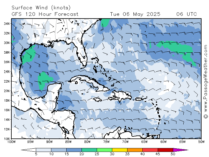
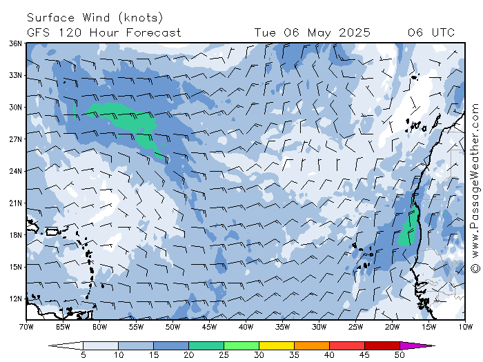
Cartes vents de PassageWeather.com dans 5 jours | Winds maps from PassageWeather.com within 5 days
Permettent de détecter une perturbation en formation | Allow to detect a disturbance in formation
Caraïbes et Golfe du Mexique | Caribbean sea and Gulf of Mexico ||| Atlantique Tropical et Afrique | Tropical Atlantic & Africa
| Prédictions de l'activité tropicale pour la saison 2018 Mise-à-jour du 19 avril 2018 | ||||
| Source | Date | Tempêtes nommées | Ouragans | Ouragans majeurs |
| Moyenne | 1981-2010 | 12,1 | 6,4 | 2,7 |
| TSR* | 7/12/17 | 15 | 7 | 3 |
| CSU* | 5/4/18 | 14 | 7 | 3 |
| TSR* | 5/4/18 | 12 | 5 | 2 |
| NCSU | 16/4/18 | 14-18 (16) | 7-11 (9) | 3-5 (4) |
| TWC | 19/4/18 | 13 | 7 | 2 |
NCSU: (moyenne entre parenthèses)
TWC: Weather Channel
* les plus réputés pour les prévisions cycloniques
MÉTÉO CYCLONIQUE :
- NHC: Tropical Weather Outlook / Bulletin du NHC. potentiel au nord du Yucatan en fin de semaine. Région possiblement menacée: Louisiane et Floride (voir ci-dessous).
- Onde(s) Tropicale(s) (OT): Une OT passe + au sud. Elle peut nous affecter marginalement. Une seconde OT est actuellement entre l'Afrique et les petites Antilles. Prévue de toucher nos îles. Arrivée Dimanche.
Ci-dessous: Probabilités de formation dans les 0 à 120 h (5 jours)

Ondes Tropicales dans 24, 48 & 72 h | Tropical Waves within 24, 48, & 72 h


MÉTÉO
- HIER & NUIT DERNIÈRE: Amélioration. Moins nuageux avec de rares averses brèves. Mer peu agitée à belle en baie. Vents devenant modéré d'Est avec encore de fortes rafales.
- OBSERVATIONS CE MATIN ENTRE vers 6-8 H. Partiellement nuageux, petites averses possibles. Vents modérés avec des rafales, légers par moments, mer belle à peu agitée en baie. Vérifiez bien la date et les heures (3 dernières heures). Pour des données actualisées cliquez sur les liens plus bas.
- DERNIÈRE MINUTE: ---
* "Frais" signifie en fait "assez fort" en langage météo et maritime et non pas "froid"...
Liens observations
http://www.iflightplanner.com/W/Wx/?ID=tncm&MPA=VAF
http://w1.weather.gov/data/obhistory/metric/TNCM.html (ne fonctionne plus actuellement)
http://w1.weather.gov/data/obhistory/metric/TNCM.html (ne fonctionne plus actuellement)
OBSERVATIONS AUTOMATIQUES (visibles seulement sur le site, pas dans les emails)
Petite dégradation temporaire du temps due à un talweg (creux) et la première Onde Tropicale de la saison approchant. Retour au même genre de temps qu'actuellement ensuite. Dégradation significative attendue pendant le weekend.
- AUJOURD'HUI: Partiellement nuageux à parfois très nuageux avec environ 60% de risques d'averses. Faible risque orageux. Vents modérés à frais 19 à 30 km/h (10-16 nd). Houle d'Est 7-8 secondes, se creusant 2-2.4 m.
- JOURS SUIVANTS: Assez beau T avec quelques averses possibles. La seconde Onde Tropicale pourrait arriver pendant le weekend: orages et fortes pluies possibles. Rappel: Les navigateurs doivent consulter avant-tout la météo marine officielle: Bulletin Côtier & Large de Meteo France.
- VENTS & MER: Les navigateurs doivent consulter avant-tout la météo marine officielle: Bulletin Côtier & Large de Meteo France. Température de la mer: 26°C.
- HOULE DOMINANTE / MER DU VENT: page houle.
- MARÉES ST MARTIN: Voir Lien.
- NAVIRES: Vessel Finder (voir les navires dans la baie).
---------------------------------------------------
- FRANCE: carte prévisions: Meteo en France
- Ci-dessous: Prévisions Foreca pour Paris / CDG
5 DAYS FORECAST
10 knots=18,52 kph=11.5 miles
Mariners should foremost consult the official marine weather: Meteo-France's offshore bulletin (in English); Coastal bulletin (in French); Anguilla Weather & NHC, Tropical Weather Discussion.
Hurricane season start on July 1st for French Antilles & June 1s for other countries including USA. However, pre-seasonal cyclones can occur.
| Predictions of tropical activity for the 2018 hurricanes season Updated on April 19, 2018 | ||||
| Source | Date | Named storms | Hurricanes | Major hurricanes |
| Average | 1981-2010 | 12,1 | 6,4 | 2,7 |
| TSR | 12/07/17 | 15 | 7 | 3 |
| CSU | 4/5/18 | 14 | 7 | 3 |
| TSR | 4/5/18 | 12 | 5 | 2 |
| NCSU | 04/16/18 |
14-18 (16)
|
7-11 (9)
|
3-5 (4)
|
| TWC | 04/19/18 | 13 | 7 | 2 |
NCSU: (average in parentheses)
TROPICAL WEATHER
- NHC: Tropical Weather Outlook. Slight potential (20%) on western Caribbean. Region possibly at risk: Louisiana and neighboring states (see below)
- A Tropical Wave is crossing the southern half of the Lesser Antilles. Another one TW is moving westward over the central tropical atlantique. Arrival during the next weekend.
LEEWARD ISLANDS
- YESTERDAY & LAST NIGHT: Partly cloudy with rare and light showers. Smooth to slight sea in the bay. Moderate easterly winds with a few occasional strong gusts.
- CURRENTLY, 6-8 am: Partly cloudy with a slight chance of light showers. Moderate easterly winds with occasional strong gusts. Slight waves in the bay with a few whitecaps. Check the date and time (last 3 hours). For updated data click on the links below.
- LAST MINUTE: brief showers around 6 am
- THUNDERSTORMS: WheatherBug Spark application and its useful mobile app.
OBS LINKS:
http://www.iflightplanner.com/W/Wx/?ID=tncm&MPA=VAF
http://w1.weather.gov/data/obhistory/metric/TNCM.html
http://w1.weather.gov/data/obhistory/metric/TNCM.html
More instable conditions due to a trough and the first Tropical Wave of the season approaching. Then, back to a partly cloudy sky with occasional showers. Next weekend, we expect some wx deterioration (possible) with the second Tropical Wave.
- TODAY: Partly cloudy to occasionally cloudy with a 60% chance of showers due to a tropical wave running further south. Low chance of thunderstorms. Easterly swell 7-8 seconds, increasing 2-2,4 m (7-8 ft) on Atlantic open waters.
- NEXT DAYS: Relatively good weather but with a chance of occasional showers. The second tropical wave could arrive during the weekend: thunderstorms and heavy rain possible.
- Mariners should foremost consult the official marine weather: Meteo-France's offshore bulletin (in English); Coastal bulletin (in French); Anguilla Weather & NHC, Tropical Weather Discussion.
- Below, relatively reliable automatic forecasts from www.foreca.com. From top to bottom: Day, date, hours, weather, temperature (in red), precipitations (inches) and winds (direction and speed in mph)
- WINDS & SEAS: Mariners should foremost consult the official marine weather: Meteo-France's offshore bulletin (in English); Coastal bulletin (in French); Anguilla Weather & NHC, Tropical Weather Discussion. Sea temperature: 25->26 ° C.
- PRIMARY SWELL / WIND SEA: See the swell page.
- TIDE, ST MARTIN: go to this Link.
- SHIPS: Vessel Finder
- OTHER INFORMATION: ---
LIENS BULLETINS MARINE / LINKS FOR MARINERS
- Voir + de détails sur meteo france marine et Meteo-France Large. Aussi BMS côtier (Bulletin Marine Spécial) si nécessaire.
- Etat de la mer avec les webcams de St Barth.
- Ci-dessous: houle à la bouée 41044 à 600 km au Nord-Est de St Martin (cliquez sur les images our les agrandir):
- Swell at buoy #41044 330 nm NE of St Martin
- Detailed forecast on meteo france marine (Fr), Meteo-France Large (Fr & En) and Anguilla (en). Look also to BMS côtier (coastal) if necessary (Special Marine Bulletin)
- Seas conditions with St Bath's webcams.
Vents et mer dans 24 h (creux en pied. 1 pied=30 cm). 1/2 barbule=5 nd. 1 barbule=10 nd)
Winds and seas within 24 h (height in feet. 1/2 barb=5 kts. 1 barb=10 kts)
Houle dans 24 h (direction et période) | Swell within 24 h (direction and period)
Autres données mer | Other seas data: https://tinyurl.com/houle-swell
webcam St Barth
Webcam simple de l'Anse des Flamands à St Barth (Flemish's bay) à 30 km au sud-est de Baie Nettlé. Se met à-jour en rafraîchissant la page. Vue vers le nord-est. Voir aussi la page des webcams.
Simple webcam at St Barth (Anse des Flamands - Flemish's bay) at 18 Miles km southeast of Baie Nettlé (or Nettle Bay). Refresh it by refreshing the page. View toward NE. See also webcams page.
SANTE | HEALTH
Actualité santé St Martin. Actualité Santé St Barth. (Health news in french). To translate it, use DeepL.com, the best automatic translator in the world!
TROPICAL CYCLONES
La saison officielle démarre le 1er Juin | Official season starts on June 1st
|
||||||||
AIDE | HELP
Raccourcis clavier pour recharger une page sans vider le cache de votre navigateur.
Keyboard shortcuts to reload a page without emptying your browser cache.
| Navigateur | Browser | Raccourcis | Shortcuts |
|---|---|
| Firefox | Ctrl + F5 ou/or Ctrl + R |
| Google Chrome | Ctrl + F5 ou/or Maj + F5 |
| Safari | Ctrl + Alt + E |
| Internet Explorer | Ctrl + F5 |
| Opera | Shift ou Maj + F5 |
https://fr.wikipedia.org/wiki/Cache_web: note: un des raccourcis donné par Wikipedia pour Google Chrome ne fonctionne plus ou pas sur Linux. Je l'ai retiré dans le tableau ci-dessus. Maj+F5 fonctionne très bien. Opera permet de personnaliser facilement les raccourcis clavier et souris.
https://en.wikipedia.org/wiki/Wikipedia:Bypass_your_cache
retour à miniNBBCmeteo