Recevoir les bulletins par courriel - Get forecasts via email
VIGILANCES & ALERTES (click image if our islands in yellow)
WATCH, WARNING & ALERT (clic sur l'image si nos îles sont en jaune)
CTRL+MAJ+R / CTRL+SHIFT+R
POUR RECHARGER COMPLÈTEMENT CETTE PAGE SANS VIDER LE CACHE...
TO COMPLETELY RELOAD THIS PAGE WITHOUT EMPTYING THE CACHE..
Salut tout le monde !
Lees hautes-pressions devraient encore générer de la stabilité aujourd'hui mais un creux va arriver la nuit prochaine augmentant les chances d'averses.
...
Hello everyone...
A dominant surface high pressure system is expected to generate stable conditions. However, instability and moisture associated with a low level trough moving into the area tonight will increase the chances of showers.
...
Photo du jour (peut changer en cours de journée) | Picture of the day (can change later)

http://104.207.144.52/videobaie.mp4 VIDEO:Tourne en boucle (loop).
Animation Infra-Rouge Caraïbes | Caribbean IR loop
| Taille d'origine / Original size |
| Sea water temp | Température mer |
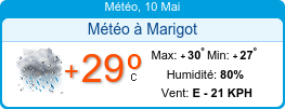
Note: le "sticker" ci-dessus peut indiquer une humidité erronée pour Marigot (environ +20%). Traduire KPH par km/h.
Si vous recevez cette page par courriel, vous ne verrez pas les images et animations satellite. Si vous voulez en profiter pleinement, cliquez ici: Bulletins du webmaster
If you receive this page by email, you will not see satellite images and loops. If you want to enjoy it fully, click here: Webmaster's forecast
10 noeuds (10 nd) = 18,52 km/h
- PRÉVISIONS SAISON CYCLONIQUE 2018:
Nouvelles prévisions. NCSU= North Carolina State University, pessimistes, prédisent une saison très active 😧
| Prédictions de l'activité tropicale pour la saison 2018 Mise-à-jour du 16 avril 2018 |
||||
| Source | Date | Tempêtes nommées | Ouragans | Ouragans majeurs |
| Moyenne | 1981-2010 | 12,1 | 6,4 | 2,7 |
| TSR* | 7/12/17 | 15 | 7 | 3 |
| CSU* | 5/4/18 | 14 | 7 | 3 |
| TSR* | 5/4/18 | 12 | 5 | 2 |
| NCSU | 16/4/18 | 14-18 (16) | 7-11 (9) | 3-5 (4) |
NCSU: (moyenne entre parenthèses)
* les plus réputés
- HIER & LA NUIT DERNIÈRE: Assez beau temps avec de rares averses. Mer peu agitée en baie. Houle s'amortissant, vents modérés d'Est env 13 noeuds (24 km/h) avec de fortes rafales occasionnelles.
- OBSERVATIONS CE MATIN: À 8 h. Partiellement nuageux avec une averse vers 6 h. Mer peu agitée en baie avec une houle légère, vents modérés d'Est 18-24 km/h (10-13 nœuds). Température 23° à 7 h. Vérifiez bien la date et les heures (3 dernières heures). Pour des données actualisées cliquez sur les liens plus bas.
- DERNIÈRE MINUTE: Averses, visibilité faible.
Liens observations
http://www.iflightplanner.com/W/Wx/?ID=tncm&MPA=VAF
http://w1.weather.gov/data/obhistory/metric/TNCM.html (ne fonctionne plus actuellement)
http://w1.weather.gov/data/obhistory/metric/TNCM.html (ne fonctionne plus actuellement)
OBSERVATIONS AUTOMATIQUES (visibles seulement sur le site, pas dans les emails)
- AUJOURD'HUI & DEMAIN: on attend un ciel partiellement ensoleillé à parfois très nuageux avec un risque d'averses accru la nuit prochaine et demain. Vents d'Est se calmant un peu et mer devenant moins agitée. De fortes rafales restent possibles.
- JOURS SUIVANTS: Des averses occasionnelles possibles surtout du soir au matin. Lundi et mardi matin: très nuageux avec de fortes chances d'averses. Ensuite, assez beau avec quelques risques d'averses du soir au matin. Vents et mer se renforçant à nouveau à partir de mardi.
---------------------------------------------------
- VENTS & MER: Vents se calmant 15-25 km/h aujourd'hui et demain. De fortes rafales restent cependant possible. Mer devenant agitée 1,5 à 1,8 m puis peu agitée à agitée 1,2-1,5 m. Possible nouveau renforcement vents et mer dès mardi. Voir Bulletin Côtier & Large de MF. La température de la mer se rapproche de 26°C.
- HOULE DOMINANTE: Bouée 41044 à 500 km au nord-est de St martin: Mer du vent (d'est). Voir page houle.
- MARÉES ST MARTIN: Voir Lien.
- NAVIRES: Vessel Finder (voir les navires dans la baie).
---------------------------------------------------
- INFO: ----
- FRANCE: carte prévisions: Meteo en France
5 DAYS FORECAST
10 knots=18,52 kph=11.5 miles
2018 HURRICANE SEASON FORECAST: NCSU (North Carolina State University) predicts a very active hurricane season
| Predictions of tropical activity for the 2018 hurricanes season Updated on April 16, 2018 | ||||
| Source | Date | Named storms | Hurricanes | Major hurricanes |
| Average | 1981-2010 | 12,1 | 6,4 | 2,7 |
| TSR* | 7/12/17 | 15 | 7 | 3 |
| CSU* | 5/4/18 | 14 | 7 | 3 |
| TSR* | 5/4/18 | 12 | 5 | 2 |
| NCSU | 16/4/18 | 14-18 (16) | 7-11 (9) | 3-5 (4) |
NCSU: (average in parentheses)
* The most famous
- YESTERDAY AND LAST NIGHT: Fine wx, partly sunny. Slight sea in the bay with subsiding swell, moderate easterly winds 11-14 knots. Temperature 25-26 °C. Moderate shower around 6 am this morning.
- THIS MORNING, at 8 o'clock. Fine wx, partly sunny to partly cloudy. Slight sea in the bay with subsiding swell, moderate easterly winds 10-13 knots. Temperature 23 °C (73.4 F) at 7 am. Check date and times (last 3 hours). For updated data click on the links below.
- LAST MINUTE: ----
- THUNDERSTORMS: WheatherBug Spark application and its useful mobile app.
OBS LINKS:
http://www.iflightplanner.com/W/Wx/?ID=tncm&MPA=VAF
http://w1.weather.gov/data/obhistory/metric/TNCM.html
http://w1.weather.gov/data/obhistory/metric/TNCM.html
- TODAY & TOMORROW: Expected partly sunny to cloudy at times with about 30% chance of occasional showers especially overnight (50%). Winds, seas and swell subsiding slightly. Tomorrow: increasing chance of showers including the night.
- NEXT DAYS: No new significant deterioration expected. Tuesday: chance of morning showers but nice wx later.The rest of the week should be relatively pleasant with only a slight shower activity, generally from dusk to dawn. Winds and seas could deteriorate a little starting Tuesday.
- WINDS & SEAS: Winds and seas calming down a little until tomorrow 15-25 km / h or 8-14 kts. Possible high gusts. Seas becoming moderate 1,5-1.8 (5-6 ft) then 1,2-1.5 (4-5 ft). Smooth to slight in the bay. New winds and seas deterioration are expected starting Tuesday. Look at Meteo-France's offshore bulletin (in English). Coastal bulletin (in French). Sea temperature: 25->26 ° C.
- PRIMARY SWELL: Buoy 41044, 500 km northeast of St Martin: Easterly wind sea only. More information in swell page.
- TIDE, ST MARTIN: go to this Link.
- SHIPS: Vessel Finder
- OTHER INFORMATION: ...
Prévisions automatiques Foreca (visible seulement sur le site, pas dans les courriels)
Foreca automatic forecast (visible only on the website, not in emails)LIENS BULLETINS MARINE / LINKS FOR MARINERS
- Voir + de détails sur meteo france marine et Meteo-France Large. Aussi BMS côtier (Bulletin Marine Spécial) si nécessaire.
- Etat de la mer avec les webcams de St Barth.
- Ci-dessous: houle à la bouée 41044 à 600 km au Nord-Est de St Martin (cliquez sur les images our les agrandir):
- Swell at buoy #41044 330 nm NE of St Martin
- Detailed forecast on meteo france marine (Fr), Meteo-France Large (Fr & En) and Anguilla (en). Look also to BMS côtier (coastal) if necessary (Special Marine Bulletin)
- Seas conditions with St Bath's webcams.
Vents et mer dans 24 h (creux en pied. 1 pied=30 cm). 1/2 barbule=5 nd. 1 barbule=10 nd)
Winds and seas within 24 h (height in feet. 1/2 barb=5 kts. 1 barb=10 kts)
Houle dans 24 h (direction et période) | Swell within 24 h (direction and period)
Autres données mer | Other seas data: https://tinyurl.com/houle-swell
webcam St Barth
Webcam simple de l'Anse des Flamands à St Barth (Flemish's bay) à 30 km au sud-est de Baie Nettlé. Se met à-jour en rafraîchissant la page. Vue vers le nord-est. Voir aussi la page des webcams.
Simple webcam at St Barth (Anse des Flamands - Flemish's bay) at 18 Miles km southeast of Baie Nettlé (or Nettle Bay). Refresh it by refreshing the page. View toward NE. See also webcams page.
SANTE | HEALTH
Actualité santé St Martin. Actualité Santé St Barth. (Health news in french). To translate it, use DeepL.com, the best automatic translator in the world!
TROPICAL CYCLONES
La saison officielle démarre le 1er Juin | Official season starts on June 1st
|
||||||||
AIDE | HELP
Raccourcis clavier pour recharger une page sans vider le cache de votre navigateur.
Keyboard shortcuts to reload a page without emptying your browser cache.
| Navigateur | Browser | Raccourcis | Shortcuts |
|---|---|
| Firefox | Ctrl + F5 ou/or Ctrl + R |
| Google Chrome | Ctrl + F5 ou/or Maj + F5 |
| Safari | Ctrl + Alt + E |
| Internet Explorer | Ctrl + F5 |
| Opera | Ctrl + F12 |
https://fr.wikipedia.org/wiki/Cache_web: note: un des raccourcis donné par Wikipedia pour Google Chrome ne fonctionne plus ou pas sur Linux. Je l'ai retiré dans le tableau ci-dessus. Maj+F5 fonctionne très bien.
https://en.wikipedia.org/wiki/Wikipedia:Bypass_your_cache
retour à miniNBBCmeteo